Timelapse footage documents snow buildup during Minnesota winter storm, highlighting rapid accumulation and travel hazards
Snow builds quickly in metro-area timelapse as storm impacts intensify across Minnesota
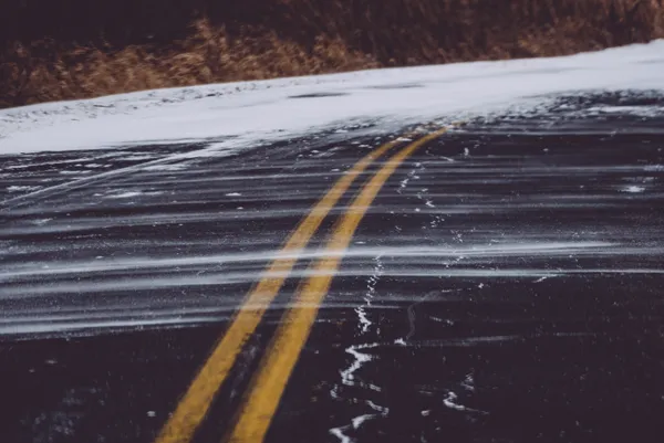
A timelapse video recorded during a recent Minnesota winter storm captures a familiar but hard-to-measure reality of snow events: accumulation can accelerate within a few hours, transforming pavement, rooftops and sidewalks from wet to fully snow-covered. The footage compresses the storm’s progression into seconds, making it easier to see when the heaviest bands moved through and how rapidly surfaces became snow-packed.
The video aligns with a broader pattern seen in multiple storms this season—periods of relatively light snowfall punctuated by bursts that quickly degrade visibility and traction. In the Twin Cities, short-duration increases in snowfall rate can be enough to overwhelm road treatment and plowing cycles, especially when temperatures hover near freezing and snow turns to slush on contact with warmer ground.
What the timelapse reveals about accumulation and timing
Timelapse imagery is not a measuring tool, but it can help reconstruct storm timing. Changes in surface color and reflectivity indicate when snow begins sticking consistently, while drifting patterns can signal wind-driven redistribution after the initial accumulation.
Onset of sticking snow: A transition from wet pavement to a uniform white cover often marks a shift in surface temperature or snowfall intensity.
Rapid coverage: The steepest visual change typically occurs during the heaviest snowfall window, when accumulation outpaces melting and compaction.
Post-snow impacts: Even after snowfall eases, wind and traffic can reshape accumulation, concentrating snow into drifts and clearing some exposed areas.
Measured totals varied sharply by location
Snowfall reports from the same mid-March period showed meaningful differences across relatively short distances. In the Twin Cities metro, reported accumulation ranged from a dusting up to about 2 inches in some neighborhoods, while several inches were reported in parts of northeastern Minnesota and western Wisconsin. Such variability is typical when a storm track places heavier bands north or east of the core metro while still producing widespread slick conditions.
Why travel impacts can outpace snow totals
Public safety impacts are often driven less by total snowfall and more by timing and intensity. A few inches falling during the morning commute can produce more crashes and delays than higher totals overnight. Transportation agencies close or restrict roadways when visibility and safety degrade to the point that travel becomes dangerous for motorists and snowplow operators.
Short periods of heavy snowfall, combined with blowing snow, can create near-whiteout conditions even when storm totals are moderate.
What residents can watch for during the next system
For drivers and homeowners, the key signals to monitor are the expected start time of sticking snow, the heaviest snowfall window, and wind forecasts that can turn falling snow into blowing snow and drifting. As the timelapse illustrates, conditions can change quickly—sometimes within a single hour—making timing as critical as totals.